From the deserts to the valleys and high plateaus, Arizona is full of hidden treasures. Where the desert meets the highlands, you'll find Four Peaks, a prominent landmark in the Mazatzal Mountains in Tonto National Forest. Approximately 40 miles northeast of Phoenix. Brown’s Peak sits at the northernmost end of the Four Peaks and is the highest-standing at 7,657 ft above sea level. The out-and-back hike (5.1 miles round-trip) on the Lone Pile trail gains 5,707 ft from the trail head and is rated difficult.
Getting There
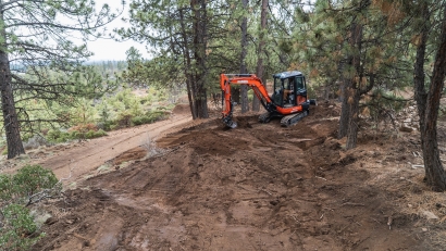
Take US Highway 87 to the Four Peaks Wilderness entrance. FR143 is a well marked dirt road on the right; 4x4 required to traverse this rough road. Travel along FR143 for 19 miles and watch as the landscape transforms. As you exit the desert flats, you'll steadily climb and to the Mazatzal Divide. Turn right on FR648/Pigeon Spring Rd and continue approximately 2 miles to the Lone Pine trail head.
[caption id="attachment_23644" align="aligncenter" width="1000"] View of Four Peaks from FR143[/caption]
Trail Summary
The trail changes scenery, flora and fauna often, starting with our first steps. The trail wound through pine forest in the foothills, and Theodore Roosevelt Lake came into view as the trail ascended deeper into the forest.
[caption id="attachment_23643" align="aligncenter" width="1000"] View of Theodore Roosevelt Lake on Lone Pine Trail to Brown's Peak. Pictured in KÜHL TEE[/caption]
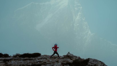
Upon exiting the lowland forest, we reached the base of the highland section and were moved by the sight of all four peaks in their full glory. The sparse terrain, minimal trees and rolling winds lend themselves to this picturesque landscape. As we laid eyes on the Four Peaks for the first time, we got the impression that these peaks could have hosted ancient gods who perched themselves atop the peaks to gaze down to the lands below.
As we trekked closer to the peaks, the terrain changed yet again with an increase in gradient and boulders we had to scramble over to reach the base of Brown's Peak. From the base, we had to navigate an 800-900 ft rockfall, nestled between Brown’s and Brother Peaks.
Some of the sections in the chute were treacherous, with vertical walls up to 15 feet high. We proceeded with caution, precariously climbing loose scree and rocks that could potentially cause a slide.
[caption id="attachment_23645" align="aligncenter" width="768"] Looking back down chute on ascent to Brown's Peak[/caption]
At the top of the rockfall, a lone tree symbolizes the start line to the final summit push. Upon summiting, we were greeted with awesome views and a front row seat to majestic hawks circling the sky above. Once we reached the top, we made sure not to miss the recordings etched into the rocks of fellow hikers’ successful summits and the opportunity to add something to the time capsule. The summit is a great place to enjoy lunch before beginning the return descent.
[caption id="attachment_23646" align="aligncenter" width="1000"] Victoire Mwema (front), Mike Garnier (back) and Nick Penna (right) on Brown's Peak[/caption]
Brown’s Peak is a must do! Varying landscapes and ecosystems, wildlife sightings, and the challenging summit approach make this hike an adventurer's dream come true.
Nick Penna was declared legally blind at the age of 16, but that hasn't stopped him from achieving his goals in international rugby and Jiu-Jitsu. In 2019, he won the IBJJF Worlds Novice Championship in the Masters 1 Ultra Heavy Weight division. More recently, he's been chasing ancient ruins throughout the mountain tops and canyons of Arizona in preparation for a summit bid of Pico De Orizaba, the highest point in Mexico and 3rd tallest mountain in North America.